| Home Search | You are not logged in. log in |
| February 2004 | I have upgraded my account with Supanames. You may experience occasional glitches with the server and there is a window during which data may disappear. It's probably best to hold off logging new trigpoints until Monday. | March 2003 | I have added a facility for users to report trigpoints. Please be sure that you are actually reporting a new trigpoint. Already existing trigpoints within 100 metres are probably the same one. You will find a link to the report form on your home page. |
| January 2003 | The searching facility has been significantly revised. You can now search on a full grid reference or a full lat/long position. Search results are ordered more or less by distance from the position specified. Grid reference searches display distances in km. I've done this because it is relatively easy to calculate the distance between two grid references, but much harder to do the same for two lat/long positions. |
| Grid references now link to streetmap.co.uk. |
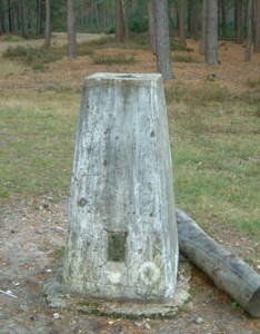
Trig points were a tool to give surveyors a frame of reference for surveying the UK in the days before electronic positioning aids were available (GPS etc). Typically, a trig point is a concrete post set on a high point such as a hill with a metal disc inset in the top which you can put your theodolite in. The trig point is at an accurately surveyed and documented position so you can survey other stuff relative to one or more trig points.
There are 6,282 trig points (plus test0001 which you can use for testing) in the database on this web site. I have no idea if that is a complete list or if all of the trig points listed here still exist. The objective is to visit the trigpoints here and then log your visit. At some point it will be possible to upload photographs as proof of your visit.
The OS grid references in the database were generated by converting the WGS84 coordinates to OSGB36 and then generating the grid reference. The algorithm used was that defined in A Guide to Coordinate Systems in Great Britain published by the Ordnance Survey. This algorithm is known to introduce errors of up to 5 metres and my implementation may not be totally debugged, which basically means do not trust the last digit of a grid reference given here. Actually, the WGS84 coordinates may not be trustworthy either.
Please note that some trig points may not be on publicly accessible land. Also, it is certain that some trig points are in remote - even dangerous - locations. If you decide to go looking for trig points you do so entirely at your own risk. I cannot take any responsibility for any trouble you might get in. Please take proper precautions when out walking and respect the wishes of owners of private land.
If you do find that a trig point is inaccessible due to private land, danger or simply not being there anymore, please add a "not found" entry so that other people are informed.
The data in this web site were kindly supplied by
Chris n Maria and were collated
from two separate sources. Trigpoints with unverified
in the name are
from an older set of data and are much less likely to exist still.